 Legacy of FIBO
Researchers and developers:
- Dr. Djitt Laowattana
- Mr. Roongrote Wangkiet
- Mr. Peter Srivaree-Ratana
Project owner:
- Ministry of Science and Technology (MOST)


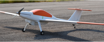
Aerial imagery is one of the most valuable information for natural resource management. The series of still images can be mosaiced together to construct a high-resolution map which can be used for investigating an interested area. Traditionally, satellite images are used for map construction. However, it is susceptible to atmospheric conditions such as cloud and fog. The operation by manned aerial vehicles, despite providing clearer images, can lead to higher operational cost. Thus, the technology of unmanned aerial vehicles is introduced to bridge the gap between those two image-acquired methods. This project focuses on the development of various UAV subsystems to support field operation.
![]()