 Legacy of FIBO
Researchers and developers:
- Dr. Djitt Laowattana
- Dr. Annop Ruangwiset
- Mr. Roongrote Wangkiet
Project owner:
- Hydro and Agro Informatics Institute (HAII)

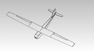
Aerial imagery is one of the most valuable information for natural resource management. The series of still images can be mosaiced together to construct a high-resolution map which can be used for investigating an interested area. Traditionally, satellite images are used for map construction. However, it is susceptible to atmospheric conditions such as cloud and fog. The operation by manned aerial vehicles, despite providing clearer images, can lead to higher operational cost. Thus, the technology of unmanned aerial vehicles is introduced to bridge the gap between those two image-acquired methods.
This project first focuses on developing method for increasing flight performances of electrical fixed-wing UAV with the aim to reduce energy consumption of propulsion subsystem. This will lead to longer endurance time. To achieve this, control algorithms taken wind into account as well as testing of various types of actuators are investigated. The other necessary subsystems such as payload and communication are also developed to support field operation.
![]()